
Aerial footage reveals destruction in coastal Venezuela
Aerial footage reveals destruction in coastal Venezuela, capturing the aftermath of two devastating earthquakes that struck the region on Wednesday, October 18, 2023. The footage, obtained through satellite imagery and drone captures, showcases the widespread damage inflicted upon La Guaira, a key coastal city located approximately 100 kilometers north of Caracas. The images reveal crumbling buildings, cracked roads, and displaced infrastructure, providing a stark visual account of the earthquakes’ impact. Officials have confirmed that the tremors, which reached a magnitude of 6.0 on the Richter scale, caused significant structural failures, particularly in multi-story residential complexes and commercial hubs. The coastal destruction is not only a testament to the raw power of the natural disaster but also a reminder of the vulnerability of Venezuela’s infrastructure to seismic activity.
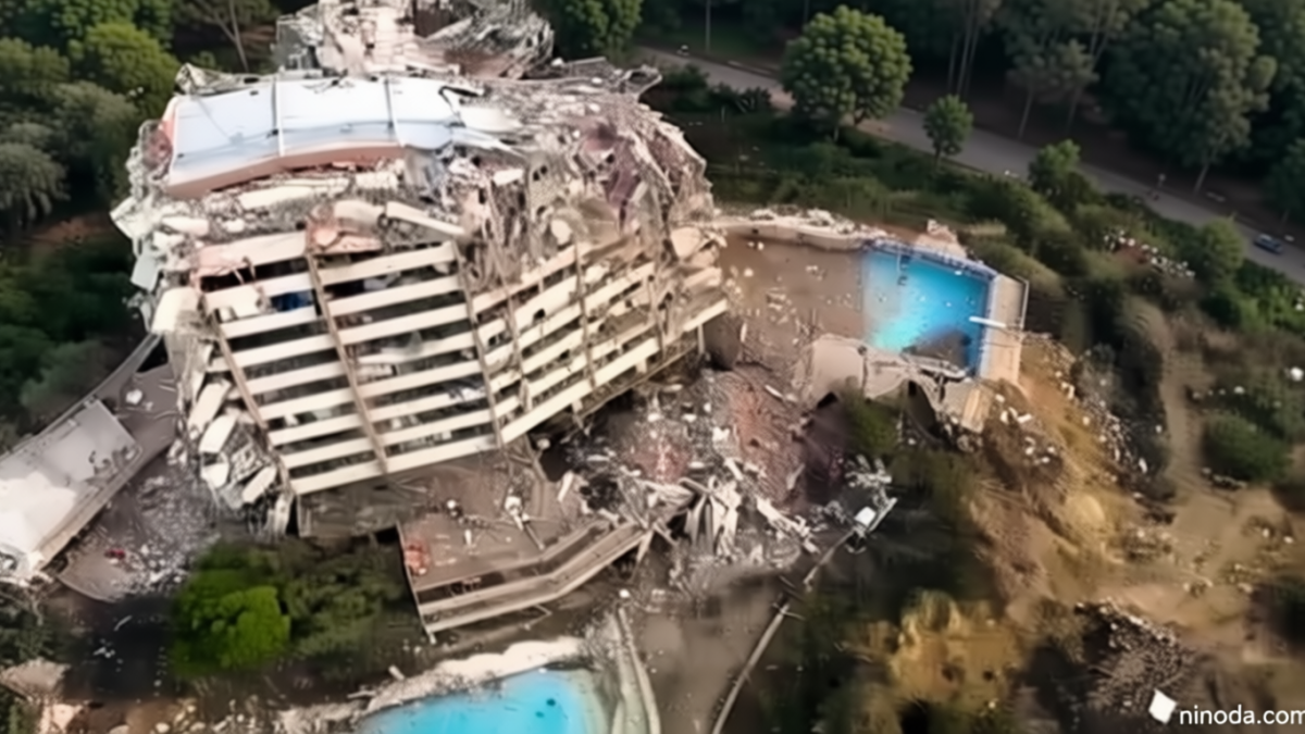
The Severity of the Coastal Damage
The coastal destruction has been particularly severe in La Guaira, where the earth’s movement exposed the fragility of buildings constructed over decades with varying standards. Aerial surveys indicate that nearly 40% of the city’s structures sustained major cracks, while several high-rise buildings have partially collapsed, trapping residents and emergency workers in the debris. The footage also highlights the disruption to critical infrastructure, including power lines, water pipelines, and transportation networks, which have been severed or damaged. In the port area, which serves as a vital economic artery for the region, warehouses and loading docks have been reduced to rubble, complicating the delivery of relief supplies. Local authorities have expressed concern over the potential for secondary hazards, such as landslides and coastal erosion, which could further exacerbate the situation.
Residents of La Guaira have described the scene as apocalyptic, with families forced to evacuate their homes in the early hours of the morning. The coastal footage reveals entire neighborhoods in disarray, with streets blocked by fallen concrete and vehicles wedged between collapsed buildings. A resident quoted in the report said, “It was like the ground had swallowed our city. We’ve never seen anything like it before.” The aerial perspective, while limited, underscores the scale of the devastation, offering a comprehensive view of the damage that ground-level observations might miss. This has sparked renewed calls for improved earthquake preparedness in Venezuela, a country that has experienced several seismic events in recent years, including a 7.3 magnitude earthquake in 2016 that claimed over 100 lives.
Emergency Response and Recovery Efforts
Following the earthquakes, emergency teams have been deployed to La Guaira to assess the damage and initiate rescue operations. The aerial footage has been instrumental in identifying the most affected zones, allowing aid workers to prioritize areas where people are still trapped or in need of immediate assistance. Initial reports indicate that at least 200 individuals have been displaced, with many seeking shelter in nearby communities. The Venezuelan government has launched a campaign to distribute temporary housing and food supplies, though challenges remain in reaching all affected areas due to damaged roads and communication networks. International organizations, including the Red Cross and UN agencies, have also pledged support, emphasizing the importance of collaborative efforts in disaster response.
Meanwhile, engineers and geologists are working to determine the exact cause of the earthquakes, which were centered near the coastal region of the Caribbean Sea. Preliminary studies suggest that the tremors were linked to the movement of tectonic plates along the boundary between the South American and Caribbean plates, a region known for frequent seismic activity. The coastal destruction in Venezuela has prompted discussions about the need for stricter building codes in coastal cities, particularly those with older infrastructure. Experts warn that without significant investment in seismic-resistant construction, future earthquakes could have even more catastrophic consequences. The footage has also been shared with regional authorities to coordinate response strategies and allocate resources effectively.
As the recovery efforts continue, the aerial footage of coastal Venezuela serves as both a record of the disaster and a tool for future planning. The images have been analyzed by urban planners and disaster management experts to identify patterns of damage and assess the resilience of the city’s buildings. This data is critical for developing targeted interventions, such as reinforcing critical infrastructure and improving emergency communication systems. The footage also highlights the importance of early warning systems in reducing casualties and damage, especially in densely populated coastal areas. While the immediate focus is on rescue and relief, the long-term implications of the disaster will likely shape Venezuela’s approach to disaster resilience and urban development in the years to come.